Coast Guard RDC Project Uses Analytics to Ensure Safe Navigation Amid Renewable Energy Development

Home / Articles / External Government

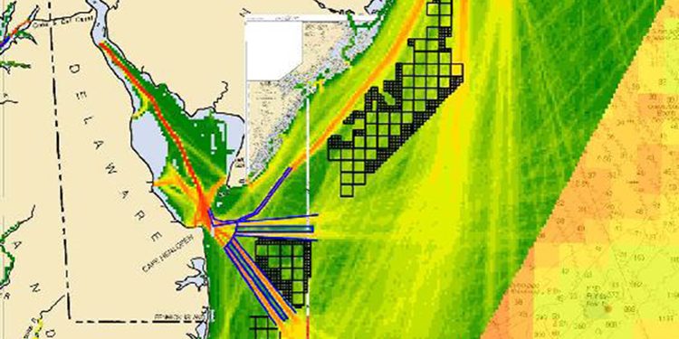
This map created from a digital tracking tool shows the density of maritime traffic in and out of Delaware Bay overlaid with black grid-blocks locating proposed wind energy areas off the coasts of New Jersey, Delaware, and Maryland. The image is from the Atlantic Coast Port Assess Route Study undertaken by the Coast Guard to address potential navigational safety risks associated with offshore wind energy development  (graphic courtesy of National Oceanic and Atmospheric Administration/MarineCadastre.gov).
This map created from a digital tracking tool shows the density of maritime traffic in and out of Delaware Bay overlaid with black grid-blocks locating proposed wind energy areas off the coasts of New Jersey, Delaware, and Maryland. The image is from the Atlantic Coast Port Assess Route Study undertaken by the Coast Guard to address potential navigational safety risks associated with offshore wind energy development (graphic courtesy of National Oceanic and Atmospheric Administration/MarineCadastre.gov).

June 23, 2021 | Originally published by United States Coast Guard on May 26, 2021

American coastlines are more than recreation and fishing destinations. They are vital to the development of trade and renewable energy. Sea space is finite, so locating offshore infrastructure, such as offshore energy facilities, is a complicated balancing act. The Coast Guard provides input to the offshore energy development planning process because every change in the offshore environment has the potential to impact navigation safety.

In December 2020, the Coast Guard Research and Development Center (RDC) completed a multiyear project that supported those capability needs, and its recommendations are already being implemented operationally. The Department of Interior’s “Smart from the Start” initiative puts an emphasis on offshore renewable energy installations such as wind turbines. Anticipating an increase in the number and scope of these projects, the Coast Guard determined that reliable tools were needed to more accurately assess the associated potential changes in navigation safety risk.

Focus Areas

Want to find out more about this topic?

Request a FREE Technical Inquiry!